‘The British initially thought Victoria’s rapid colonisation in the 1830s was illegal, and were concerned by its violence,’ read Kate Ashton’s article and a view a video clip from the Yoorrook Justice Commission here on ABC News, Victoria, 5 April 2024: https://www.abc.net.au/news/2024-04-05/victoria-colonisation-history-yoorrook-aboriginal-massacres/103658322
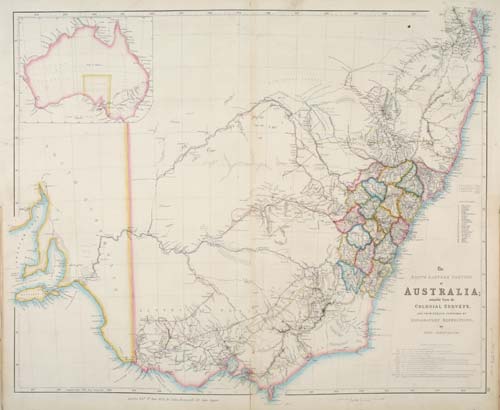
“The South Eastern Portion of Australia”; compiled from the Colonial Surveys,
and from details furnished by “Exploratory Expeditions”.
Detailed map of New South Wales, issued from the London Atlas by John Arrowsmith.
The “newly formed” counties are marked, as are the inland expeditions made 1817–1840.
Secondary Source: https://en.wikipedia.org/wiki/Nineteen_Counties
This map shows the “Nineteen Counties” of the colony of New South Wales in 1829. Read more on Wikipedia: https://en.wikipedia.org/wiki/Nineteen_Counties
Colonists were not permitted to take up land and permanent residence beyond “the Limits of Location”, i.e. beyond the Nineteen Counties. Permanent expansion to “Victoria”, then known as “the District of Port Phillip”, was forbidden.