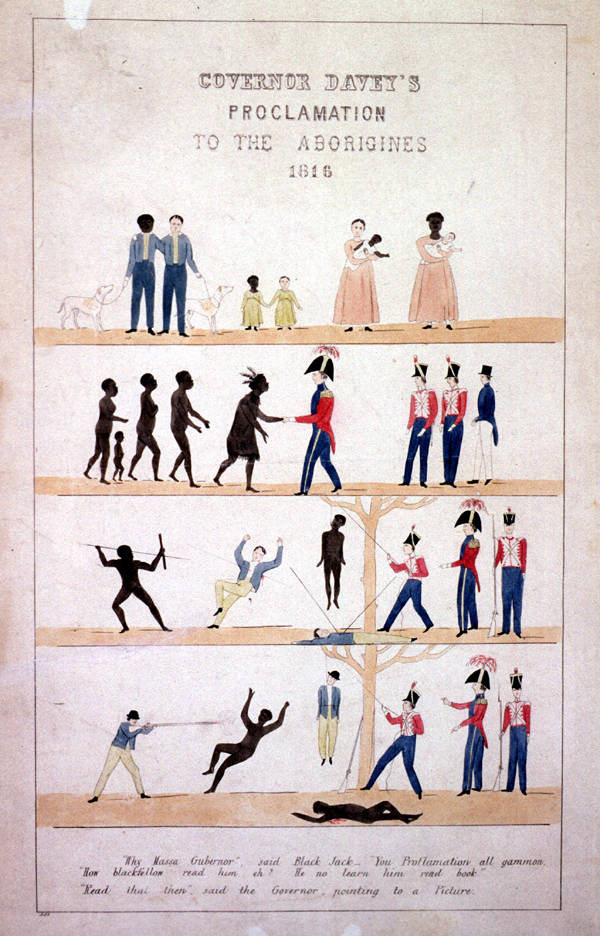
This proclamation to the Aborigines of Van Diemen’s Land was actually from Governor Arthur, not Davey. The proclamation was supposed to promote harmony between colonists and Aboriginal people, but was ineffectual. Conflicts developed to such an extent that Martial Law was declared.
Some main sources for information about conflicts in Tasmania and their locations in this list include publications such as:
A History of Tasmania, Henry Reynolds, Cambridge University Press, 2012
Baptised in Blood: the shocking secret history of Sorell, Robert Cox, Wellington Bridge Press, north Hobart, Tasmania, 2010
Black War: the Extermination of the Tasmanian Aborigines, Clive Turnbull, FW Chesire, Sydney, 1948
Broken Spear: The untold story of Black Tom Birch, the man who sparked Australia’s bloodiest war, Robert Cox, Wakefield Press, 2021
*Clements Compendium:
PDF database of attacks on and by Aborigines in southeast Tasmania, 2021:
https://rdp.utas.edu.au/metadata/484c2b53-776b-41da-8bb7-49ded4e96ea2
Fate of a Free People: the classic account of the Tasmanian Wars, Henry Reynolds, Penguin, 1995 and 2004
Friendly Mission: The Tasmanian Journals and Papers of George Augustus Robinson, 1829–1834, edited by NJB Plomley. First published 1966, reprinted 2008.
Reading Robinson: Companion Essays to George Augustus Robinson’s Friendly Mission, Anna Johnston and Mitchell Rolls eds, Monash University Publishing, Clayton, Victoria, 2012
Tasmanian Aborigines–A history since 1803, Lyndall Ryan, Allen & Unwin, 2012
The Aboriginal Tasmanians, Lyndall Ryan, Allen & Unwin, 1996
The Black War: Fear, Sex and Resistance in Tasmania, Nicholas Clements, Queensland University Press, 2014
The journals of George Augustus Robinson, Heritage Matters, Melbourne, 1998–2000
The Killing at Risdon Cove, WF Refsahuge, Australian Scholarly Publishing, 2016
The Vandemonian War: The secret history of Britain’s Tasmanian invasion, Nick Brodie, Hardie Grant Books, 2017
Tongerlongeter: First Nations Leader and Tasmanian War Hero, Henry Reynolds and Nicholas Clements, New South Books, 2021
Van Diemen’s Land: An Aboriginal History, Murray Johnson and Ian McFarlane, New South Publishing, 2015
‘Van Diemen’s Land, 1826–1831’ in The Australian Frontier Wars 1788–1838, John Connor, UNSW Press, 2002, pp. 84–101
________________________________________________________________________________________________________
*The Clements Compendium should be read with the list of Some Known Conflicts in Tasmania below, as the Compendium includes more details of violent attacks on Aboriginal people in the Oyster Bay and Big River areas of Tasmania between 1804 and 1831, and of violence against colonists in the Oyster Bay and Big River territories between 1823 and 1831.
________________________________________________________________________________________________________
For more references and sources see the Bibliography and Journal Articles, also under Resources in the main menu: Books, Databases, Films, Memorials and Monuments, Podcasts, Videos, and Warriors.
To see a map of conflicts that happened in Tasmania, please follow this link. All coordinates are approximate. This map is still being developed and does not fully reflect the places in the following list because of name changes, difficulty confirming some locations and new research that includes more locations of conflicts between colonists and First Nations people in Tasmania.
Many thanks to readers who email information about colonial frontier conflict sites. Locations will be added to the list below as new information is found and time permits. If you know of incidents that occurred, but are not included in the list below and wish to contact the author of this website, please use the form on the Contact page.
WARNING: Viewing this list may be offensive and upsetting to some readers as it contains placenames and sites where killings took place duing the frontier period in Tasmania.
Date | Location |
|---|---|
7 March 1772 | Frederick Hendrick Bay, now Marion Bay, East of Dunalley; and North Bay, TAS Aboriginal man killed in violent struggle between French explorers and First Nations people at North Bay.Marion Bay was named for Marc-Joseph Marion du Fresne, the first European to encounter Tasmanian Aboriginal People at North Bay. On 7 March 2022, 250 years after the French first encountered Tasmanian Aboriginal people, Rodney Dillon, Co-chair of the Tasmanian Regional Aboriginal Communities Alliance, called for Marion Bay to be renamed to honour the fallen Aboriginal man who was defending his Country, rather than du Fresne. Adam Langenberg has written more about this story on ABC News online, 7 March 2022: https://www.abc.net.au/news/2022-03-07/250-years-marion-bay-first-contact-europeans-tas-aboriginal/100886280 |
2 January 1804 | Port Dalrymple near modern-day Hobart, TAS |
5 February 1804 | River Derwent, TAS |
3 May 1804 | Risdon Cove on Risdon Creek off River Derwent, TAS |
November 1804 | Tamar River (Kanamaluka), (River Tamar), TAS |
1804–1806 | Tamar River (Kanamaluka), (River Tamar), TAS |
1805–1806 | River Derwent, Hobart, TAS |
2 March 1807 | River Derwent, TAS |
19 April 1807 | Hobart, TAS, on the eastern shore |
1807–1808 | Tasmania, southern interior |
1809 | Tasmania, northern and southern interior |
1810 | Southern Tasmania |
29 January 1810 | Blackman's Bay, south of Kingston, TAS |
1813 | Tasmania, southern interior |
November 1815 | Oyster Bay, east coast, TAS |
8 November 1815 | Morgan's property on Scantling's Plains (York Plains), TAS |
1817 | Hobart, TAS |
August 1817 | New Norfolk, TAS |
1817–1818 | York Plains; Pittwater (Sorell), TAS |
1818 | Near Hobart, TAS |
November 1818 | Great Swanport (Swansea), east coast, TAS |
28 November 1818 | 10 kms north-east of Triabunna on Grindstone Bay, TAS |
13 March 1819 | Near Hobart, TAS |
13 March 1819 | River Plenty (Plenty River), (tributary of Derwent south of) New Norfolk, TAS |
18 March 1819 | Tea Tree Brush, Eastern Tiers, TAS |
20 March 1819 | Oyster Bay, TAS |
April 1819 | Tea Tree Brush, Eastern Tiers, TAS |
10 April 1819 | George Town (eastern bank of Tamar River mouth), northern TAS |
17 April 1819 | Junction of Isis and Macquarie Rivers, TAS |
18 July 1822 | Reiby's farm near George Town, TAS |
30 November 1822 | Tasmania, the Interior |
1823 | James Hobbs's farm, Eastern Marshes, TAS |
15 Nov 1823 | Sally Peak, 10 kms from Bushy Plains, East Coast near Grindstone Bay, TAS |
1824 | Sorell Plains (now Hamilton), 20 kms north-west of Hobart, TAS |
26 March 1824 | Mrs Collins' farm, Blue Hills, headwaters, Coal River, north-east of Hobart, TAS |
10 June 1824 | Jericho, 10 kms south of Oatlands, TAS |
16 June 1824 | Oaks's farm, Murderers Plain, TAS |
15 June 1824 | Triffet's farm, Big River (Ouse River), TAS |
23 July 1824 | Meredith's farm, at Swanport (Swansea), 20 kms north-east of Triabunna, TAS |
10 December 1824 | Cape Portland (Lumaranatana), 55 kms north-east of Scottsdale, TAS |
25 February 1825 | Hobart Town Gaol, TAS |
13 March 1825 | Jonathan Kinsey's farm, Tooms Lake, Upper Macquarie River, TAS |
April 1825 | Hobbs' farm, McGills Marsh, TAS |
September 1825 | Green Water Ponds (Kempton), TAS |
September 1825 | Tasmania, the Interior |
December 1825 | Dairy Plains, Meander River, TAS |
1826 | Clarendon, 25 kms south-east of Launceston, TAS |
1826 | Hobart Town Gaol, TAS |
January 1826 | Burn, Pitcairn and McCarthy's farm, Clyde River, 10 km east of Bothwell, TAS |
14 March 1826 or 1827 | Great Swanport (Swansea), east coast, TAS |
1826 | Penny Royal Creek (now Liffey River) and Macquarie River south of Launceston, TAS |
April 1826 | Paddy Hart's farm, Oyster Bay, TAS |
29 April 1826 | Browning and Smith's farm near Bridgewater, TAS |
12 September 1826 | Mrs Mary Smith's farm, Pipers Lagoon, 40 kms north-north-east of Launceston, TAS |
13 September 1826 | Hobart, TAS |
23 September 1826 | Northern Tasmania |
10 October 1826 | Nicholson and Allardyce's farm on the Clyde River, 25 kms east of Oatlands, TAS |
3 November 1826 | Thompson and Pitcairn's farm, Hermitage, Shannon River, TAS |
7 November 1826 | Simpson's farm, Penny Royal Creek (now Liffey River), south of Launceston, TAS |
7 November 1826 | L. Gilles's farm, Elizabeth River near Campbell Town, TAS |
11 November 1826 | George Taylor's farm, Millers Bluff (north-west of Lake Sorell), TAS |
21 November 1826 | John Riseley's farm, Cockatoo Valley near Bothwell, TAS |
22 November 1826 | Downie's farm about three miles (c. 4.8 kms) from Allenvale, TAS |
29 November 1826 | Tasmania wide. Magistrates authorised to use force against Aborigines following alleged killing of 18 colonists. Press considers notice a declaration of war. |
19 December 1826 | Thomas Faro's farm, near Pipers Lagoon, TAS |
After 19 Dec 1826 | Mrs Smith's farm (location not given), TAS |
December 1826–April 1828 | Tasmania |
December 1826 | Paterson's Plains (St Leonards) near Launceston, TAS |
9 December 1826 | Bank Hill Farm, headwaters of Sorell Rivulet, Pittwater, TAS |
March 1827? | Bull's Grant on Middle Plain, Meander River, TAS |
Late January 1827 | Central Plateau, border of Settled Districts, TAS |
1 February 1827 | Talbot's farm, St Paul's Plains (Avoca), 50 kms north-east of Campbell Town, TAS |
6 February 1827 | Dunedin, (New Norfolk?), Norfolk Plains (Longford) south of Shannon Point, TAS |
21 February 1827 | Eastern Midland Plain, TAS |
23 February 1827 | Grant's station, Launceston district, TAS |
March 1827 | Great Swanport (Swansea), near Oyster Bay, TAS |
March 1827 | Great Swanport (Swansea), near Oyster Bay, TAS |
12 April 1827 | Mount Augustus, near Campbell Town, TAS |
12 April 1827 | Rear of David Murray's farm, Elizabeth River, Eastern Midlands, TAS |
Early May 1827 | Great Swanport (Swansea), near Oyster Bay, TAS |
May 1827 | TC Simpson's farm, Mersey River south of Latrobe, TAS |
May 1827 | Sally Peak, 10 kms from Bushy Plains on border of Prossers Plains, TAS |
24 May 1827 | William Brumby's farm, Lake River, 10 km south of Poatina, TAS |
12 June 1827 | Dairy Plains, TAS |
23 June 1827 | TC Simpson's station, Quamby Bluff/Laycock Falls (Liffey Falls), near Deloraine, TAS |
23 to 30 June 1827 | Meander River, TAS |
After 23 June 1827 | Laycock Falls (Liffey Falls) at base of Quamby Bluff, south-east of Deloraine, TAS |
After 23 June 1827 | Quamby Bluff, Western Marshes, TAS |
After 23 June 1827 | Quamby Brook, TAS |
After 23 June 1827 | Quamby Bluff, TAS |
After 23 June 1827 | Western Marshes area, TAS |
Late June 1827 | Blackman('s) River, TAS |
29 June 1827 | Herbert Chapman's farm, Glenmore (Long Swamp), 5 kms south of Westbury, TAS |
End of June 1827 | Field's Station, Quamby Bluff/Laycock Falls, TAS |
1 July 1827 | Widowson's farm, Quamby Bluff/Laycock Falls (Liffey Falls), TAS |
1 July 1827 | Walker's farm, Quamby Bluff/Laycock Falls (Liffey Falls), TAS |
1 Sept 1827–30 March 1828 | Tasmania, Settled Districts |
12 September 1827 | GC Clark's farm, Launceston, TAS |
October 1827 | Green Ponds (Kempton), 10 kms south-east of Bothwell, TAS |
24 October 1827 | Presnell's farm, St Peter's Pass near Oatlands, TAS |
27 October 1827 | Andrew Birrell's station, Tamar River, 22 kms south of Launceston, TAS |
November 1827 | Western Marshes, TAS |
10 November 1827 | Littleton's and Bryan's stations, Western River, at Glenmore (Long Swamp), TAS |
10 November 1827 | Lawrence's farm, Lake River, 10 kms south-east of Poatina, TAS |
17 November 1827 | Eastern Marshes, TAS |
17 November 1827 | Amos's farm, Oyster Bay, TAS |
20 November 1827 | Settled Districts, TAS |
About 22 November 1827 | Meander River, TAS |
About 22 November 1827 | Western Lagoon near Brumby Creek, TAS |
22 November 1827 | Richard Dry's farm, Western River, TAS |
24 November 1827 | Guilder's farm, Black Wall, West Tamar River near Launceston, TAS |
24 November 1827 | A Thompson's farm, West Tamar River 5 miles (c. 8 kms) from Launceston, TAS |
December 1827 | Junction of Brumby Creek and Lake River, TAS |
December 1827 | Cape Grim, north-west Tasmania |
December 1827 | Dairy Plains on road from Launceston to Circular Head, TAS |
December 1827 | Ritchie's Hut, Meander River, TAS |
December 1827 | Sorell Valley headwaters, TAS |
15 December 1827 | Eastern Midland Plain, TAS |
16 December 1827 | South Esk River 4 miles (c. 6.4 kms) from Launceston, TAS |
1828 | James Triffet's station, Bothwell district, TAS |
1828 | Kemp's station, Lake Sorell, north-west of Oatlands, TAS |
January 1828 | Cape Grim, north-west Tasmania |
February 1828 | Bagdad, 15 kms north of Bridgewater, TAS |
9 February 1828 | Cape Grim, north-west Tasmania |
16 February 1828 | On the road at Constitution Hill, 20 kms north of Bridgewater, TAS |
March 1828 | Macquarie River, Eastern Midland Plain, TAS |
4 March 1828 | Miles Opening, on the Aboriginal road between Bothwell and Jericho, TAS |
4 March 1828 | John Franks's farm at Quoin Hill, 20 kms north of Bridgewater, TAS |
5 March 1828 | Report of attack at Jordan Lagoon, TAS |
13 March 1828 | Staynes and Troy's station, Elizabeth River near Campbell Town, TAS |
15 March 1828 | Home's (Holmes's?) station, 26 kms south of Campbell Town near Ross, TAS |
19 March 1828 | Bullock Hunting Ground, Tamar River, TAS |
20 March 1828 | Hill's farm, 26 kms south of Campbell Town near Ross, TAS |
20–24 March 1828 | Prensell's farm, at Black Brush or Ross Bridge, south of Campbell Town, TAS |
30 March 1828 | Robertson's farm, Elizabeth River near Campbell Town, TAS |
April 1828 | Elizabeth River, Eastern Tiers, TAS |
11 April 1828 | Giles Cotterell's farm, Macquarie River near Cressy, TAS |
15 April 1828 | Van Diemen's Land (Tasmania) officially divided into Settled and Unsettled Districts |
July 1828 | Eastern Tiers, TAS |
27 July 1828 | Coulston's station, Dilston, East Tamar River, 15 kms n-w of Launceston, TAS |
July–October 1828 | Oatlands area, TAS |
27 August 1828 | George Kemp's farm, Lake Sorell, TAS |
September 1828 | Burghley [Park?], TAS |
6 September 1828 | Wilkinson's farm, Swanport (Little Swanport), 20 kms north of Triabunna, TAS |
12 September 1828 | Kitty's Corner, TAS |
21 September 1828 | John Stacey's farm, Birchall's Bottom, Sorell, 20 kms north-east of Hobart, TAS |
October 1828 | James Triffet's station, Bothwell district, TAS |
9 October 1828 | Patrick Gough's farm, Big Lagoon, Oatlands, TAS |
20 October 1828 | Green Ponds (Kempton), TAS |
20 October 1828 | Thomas "Landford's" farm, Green Ponds (Kempton) north of Oatlands, TAS |
25 October 1828 | Captain Glover's farm, Second Sandspit, Maria Island, TAS |
29 October 1828 | Gordon's farm, Bream Creek near Carlton, 20 kms east-south east of Sorell, TAS |
1 November 1828 | Martial Law Proclaimed in Settled Districts, Tasmania |
November 1828 | Ritchies' farm, Western River, TAS |
9–10 November 1828 | Jerusalem (Colebrook), 20 kms north of Sorell, TAS |
1 December 1828 | Adam Woods' farm, Magills Marsh (McGills Marsh), Eastern Marshes, TAS |
4 December 1828 | Earls's farm, Woodlands Lagoon, Eastern Marshes, TAS |
6 December 1828 | Tooms Lake, source of the Macquarie River, mountains Eastern Tasmania, TAS |
7 December 1828 | Cowie farm, Break O'Day Plains, 10 kms south-west of St Marys, TAS |
7 December 1828 | Talbot's farm, Break O'Day Plains, 10 kms south-west of St Marys, TAS |
13 December 1828 | Michael and Henry Jones's farm, Sideling Hill, Black Marsh, TAS |
27 December 1828 | Meredith farm, Swanport, 20 kms north-east of Triabunna, TAS |
13 December 1828 | Sugar Loaf Hill, Black Marsh, TAS |
1829 | Clyde River (River Clyde) near Den Hill, TAS |
1829 | Regent Plains (Regents Plain), TAS |
1829 | David Williams's farm (location not given), TAS |
January 1829 | Break O'Day Plains, TAS |
January 1829 | St Paul's River, south of Bothwell, TAS |
January 1829 | South of Bothwell, TAS |
16–30 January 1839 | Meredith Allen's farm, Swanport, 20 kms north-east of Triabunna, TAS; Lyne, TAS |
17 January 1829 | Bothwell, TAS |
January–March 1829 | East coast Tasmania |
18 February 1829 | Pleasant Hills near Beaconsfield, western side Tamar River, TAS |
February/March 1829 | Cruttenden's farm, Carlton, 10 kms south-east of Sorell, TAS |
March 1829 | Richmond, Coal River, TAS |
12 March 1829 | McGee's station, Piper River, 20 kms east of Georgetown, TAS |
13–17 March 1829 | North Esk River near Launceston, TAS |
March 1829 | Cataract Gorge, 15 minutes' walk from the centre of Launceston, TAS |
28 March 1829 | Jones and Ouse Rivers, TAS |
4 April 1829 | Major Gray's farm, St Paul's Plains, 30 kms north-west of Campbell Town, TAS |
2 May 1829 | White Marsh, Bushy Plains near Pittwater, TAS |
13 May 1829 | Mary Smith's farm, St Paul's Plains, 30 kms north-west of Campbell Town, TAS |
10 June 1829 | South Esk River, about 3 miles (c. 4.8 kms) from Kearney's grant, TAS |
June 1829 | Pittwater, TAS |
6–7 June 1829 | R Dodge's farm, Carlton, 10 kms south-east of Sorell, TAS |
12 June 1829 | Downs's station, Pittwater, TAS |
9–14 August 1829 | Jerusalem (Colebrook) and Coal River north of Sorell, TAS |
10 August 1829 | Brown Mount, Kangaroo River, 20 kms north of Sorell, TAS |
21 August 1829 | Van Diemen's Land (VDL) Co., Emu Bay (Burnie), TAS |
23 August 1829 | Dodge's Station, Carlton, 10 kms south of Sorell, TAS |
25 August 1829 | Harte's station, Little Swanport, 20 kms south of Triabunna, TAS |
1 September 1829 | East of Ben Lomond, TAS |
9 September 1829 | Espie's farm, Bashan Plains, c. 90 kms north-northwest of Hobart, TAS |
14 September 1829 | Bayles' or Bailey's farm, Macquarie River, 20 kms north-east of Oatlands, TAS |
18 September 1829 | Thomas Coffin's station, Sorell, TAS |
October 1829 | Clyde and Ouse Rivers, TAS |
October 1829 | Stokell's farm, Brown Mount, Jerusalem (Colebrook), TAS |
7 October 1829 | Jamison's and Triffet's farm, Maguires Marsh, Ouse River, TAS |
1 November 1829 | Nicholas Newport's farm, Lower Clyde, TAS |
1 November 1829 | Dixon's farm, Green Valley, TAS |
6 November 1829 | Lieutenant Fry's farm, Deep Gully, New Norfolk, TAS |
Before 1830 | Major Grey's farm, Avoca, 50 kms south-east of Launceston, TAS |
Before 1830 | Captain Wood's station, The Lakes, 45 kms north-west of Bothwell, TAS |
Before 1830 | Haasts's station, Great Twaid Port (Great Swanport? -- Swansea?), TAS |
1830 | Talbot's farm, Break O'Day, 10 kms from St Marys, TAS |
February 1830 | Clyde/Ouse Rivers, TAS |
9 February 1830 | F Bell's farm, Black Marsh, Ouse River, TAS |
11 February 1830 | Great Jordan Lagoon, TAS |
11 February 1830 | Reed's farm, Clyde, near Bothwell, TAS |
17 February 1830 | Poole's farm, Green Ponds (Kempton), TAS |
21 February 1830 | Plaistowe's farm, Constitution Hill, 20 kms north of Bridgewater, TAS |
March 1830 | Nairne's farm, Jerusalem (Colebrook), TAS |
10 March 1830 | Clyde River (River Clyde), TAS |
14–20 March 1830 | W Gee's farm, Pipers River, 20 kms north of Launceston, TAS |
18 April 1830 | ML Smith's farm, Whiteford Hills, Meander River, 20 kms south of Oatlands, TAS |
21 April 1830 | Nairne's farm, Coal River, Jerusalem (Colebrook), 54 kms from Hobart, TAS |
23 April 1830 | Addey's farm, Little Swanport River, 20 kms south of Triabunna, TAS |
23 May 1830 | D Lord's farm, Sam the Butcher Marsh, Eastern Marshes near Campbell Town, TAS |
June 1830 | Olding's farm, Prossers Plains, 20 kms south-west of Triabunna, TAS |
10 June 1830 | Captain Wood's farm, south of Regents Plain, Lake River and Cressy, TAS |
4 August 1830 | Howell's farm, Shannon, south of Great Lake, TAS |
22–27 August 1830 | Clyde River (River), TAS |
22–27 August 1830 | James Hooper's farm, Black Marsh, TAS |
8 September 1830 | Meredith's farm, Boomer Creek, Oyster Bay, TAS |
10 September 1830 | Swan Bay, West Tamar River, north of Launceston, TAS |
21 September 1830 | Thomas Gee's farm, Pipers River, 20 kms north of Launceston, TAS |
24 September 1830 | Major Gray's farm, Blackman's Corners, north-east of Campbell Town, TAS |
30 September 1830 | George Scott's farm, Mt Morrison station, Macquarie River, TAS |
1 October 1830 | The Black Line: Martial Law extended across Tasmania |
7 October–30 November 1830 | Settled Districts of Tasmania |
16 October 1830 | Stacey's farm, Sorell, 20 kms north of Hobart, TAS |
17 October 1830 | Gilder's farm, Stoney Creek, Tamar River, north-west of Launceston, TAS |
22–28 October 1830 | Butler's station, Retreat/Westbury, 10 kms north-northwest of Lillydale, TAS |
16 November 1830 | Captain Wright's farm, north bank of the south Esk River, north of Fingal, TAS |
1831 | Launceston, TAS |
27–29 January 1831 | Patrick McCasker's farm, Dairy Plains, Southern Tier Retreat, TAS |
20 March 1831 | WE Lawrence's farm, Lake River, 10 kms east of Poatina, TAS |
9 May 1831 | Kemp's Station, Lake Sorell, 25 kms north-west of Oatlands, TAS |
5–6 June 1831 | Evans' and Bell's farm, Native Hut Creek, Ouse River, TAS |
31 August 1831 | BB Thomas's farm North Down (Northdown), 10 kms east of Devonport, TAS |
December 1830–February 1835 | Conflicts over the whole of Tasmania |
© Compiled by Jane Morrison 2015, 2016–2022. Page updated 18 October 2021, 3 June 2022, 6 July 2022, 5 October 2022.